


Le Franois Sansle Mt des Ifs

drarep
User
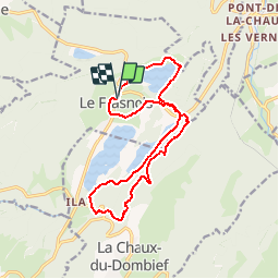

Length
15 km

Max alt
991 m

Uphill gradient
467 m
Km-Effort
21 km

Min alt
748 m

Downhill gradient
468 m
Boucle
Yes
Creation date :
2017-08-01 00:00:00.0
Updated on :
2017-08-01 00:00:00.0
4h37
Difficulty : Difficult

FREE GPS app for hiking
 SityTrail
IGN / Geographical institutes
SityTrail Plus
The world is yours!
About
Trail Walking of 15 km to be discovered at Bourgogne-Franche-Comté, Jura, Le Frasnois. This trail is proposed by drarep.
Description
Super balade
Positioning
Country:
France
Region :
Bourgogne-Franche-Comté
Department/Province :
Jura
Municipality :
Le Frasnois
Location:
Unknown
Start:(Dec)
Start:(UTM)
721941 ; 5169005 (31T) N.
Comments